2019 Abacos Trip
Another trip to the Abacos, one of our favorite places. Last year we didn’t cruise as the first 6 months of the year was tied up in a remodeling project (house not boat). This year, we snuck in a 3-1/2 week trip, returning slightly early than planned to take care of some family matters. Some system issues, mainly the house batteries starting to fail, also pushed us to take a crossing window as it presented itself. Nevertheless, it was an enjoyable trip.
2019 Chart
Trip Plan, 2019 - Abacos

                          Latitude    Longitude   dist  degT  days  Arrive      StatusAct. ncum. nm
Soverel Marina            26 50.8 N   80  4.1 W                     25-Apr-19  done
Lake Worth Inlet          26 45.8 N   80  2.6 W     5   165     1   26-Apr-19  done           5
Old Bahama Bay, West End  26 42.1 N   78 59.5 W    57    94     1   27-Apr-19  done          62
Great Sale Cay            26 58.6 N   78 13.0 W    45    68     1   28-Apr-19  done   62    124
Crab Cay                  26 55.2 N   77 35.5 W    34    96     1   29-Apr-19  done         157
Crab Key / Manjack        26 48.9 N   77 22.0 W    14   117     4   03-May-19  done         171
Water Point               26 36.2 N   77 11.0 W    16   142     3   06-May-19  done         187
Marsh Harbour             26 32.9 N   77  3.4 W     8   116     2   08-May-19  done         194
Tilloo Pond               26 27.0 N   76 59.8 W     7   151     1   09-May-19  done   7     201
Fisher's Bay              26 40.0 N   77  7.2 W    15   333     2   11-May-19  done         216
Coco Bay                  26 47.3 N   77 20.5 W    14   301     1   12-May-19  done   16    232
Green Turtle Club         26 46.9 N   77 20.2 W     0   145     1   13-May-19  done   8     240
Great Sale Cay            26 58.6 N   78 12.9 W    49           4   17-May-19  done         289
Old Bahama Bay, West End  26 42.1 N   78 59.5 W    45   248     1   18-May-19  done   62    351
Soveral Marina            26 50.8 N   80  4.1 W    58   279     1   19-May-19  done   66    417

                                                  403
2019 Abacos Trip
At last count, we have visited the Abacos on over 10 trips since the 90’s. While every cruising area has its charms, you can’t beat the northern Bahamas for secure anchorages, wonderful scenery, excellent climate, and ease of access from South Florida. With marinas, restaurants, marine services and tourist attractions available when you want them, it is also a great place to anchor in a remote area, swim off the boat, and just be laid back for weeks at a time.
It is also a place full of new things to discover. On this trip, we explored the hiking opportunities off the beach at Crab Cay, a new way (to us) to access the ocean beach on Manjack, the ridge trail on Tilloo above the pond, and the remnants of an old camp in the Water Cay area. We also thoroughly explored Green Turtle Cay via foot and golf cart while at the dock at Green Turtle Club for a few days.
After a night anchored near the Lake Worth inlet, we left in the dark and made good time to West end. The winds were forecast 15-20 from the NW/NE but seemed lighter than that, but the 4-5′ seas made for a lumpy and wet crossing. Waiting wasn’t much of an option with strong East winds coming for the next week. Old Bahama Bay is fully open again, including the restaurant, but clearing in is a little more complicated as customs officials now actually board your vessel – a long walk around the basin from the office. It was hot, so we splurged for the $28 electrical hookup and ran the air conditioning through the night.
The tide was not with us to use the Indian Cay Channel, so rather than wait until noon or so for mid tide, we left early and rounded memory rock enroute to Great Sale. This adds 15 miles to the trip, but the early start got us there just as it was getting dark and we anchored close to the eastern edge of the bight. With an incoming weather system, we did not dally there and next morning made the transit to the Crab Cay anchorage where we spent 4 days, waiting for the winds to die down. Sharing the anchorage with about 10 other boats (a lot for there), we did some snorkling around the boat and took the dinghy into the beach. A trail goes over to a rocky overlook where you can see south to the Manjack area.
From Crab we moved to Manjack for 3 days, overlapping with friends John and Carla on Reverie, who were heading home after a month in the Exumas. Great snorkling on the two wrecks along the shore in the anchorage, with thousands of fish, including parrot fish that were at least two feet long.
Next stop, after traversing the Whale Cay passage was Water Point. There were 2 or 3 other boats in the area, but anchored so far away it was like having the place to ourselves. Over a couple of days, we explored all the little bays and beaches, and found a trail leading to an old camp on one of the small islets. There is a well developed channel leading to a marina basin that was all lit up at night, but we saw no activity there. Google supplied some background – this was being developed as a port area for supplying material and workers to Bakers Bay, but they had a falling out with the owners and everything is on hold.
From there we went to Marsh Harbour for a day, picked up some supplies and got a new BTC sim card. Using an old Galaxy-3 phone that could use the micro-sim we had as a hotspot, internet connectivity was good but not great. The new nano-sim fit into our newer Galaxy-8 and performance became excellent. We also had drinks and conch fritters at Blue Hole (used to be Curly Tails), and dinner at Mangoes (which was closed on the last trip in 2017).
The house batteries during the trip had been starting to fail. Bought new in 2003, they had tested OK before we left, but the 16 years of use started catching up to them and the engine was cranking slower and slower as the days progressed. After using only about 20 AH on one bank, the voltage had dropped to 11.4 over night in Marsh -clearly a problem. Replacing these large Group 31 Gel Cells in the Abacos was not going to happen, so instead we bought an outrageously expensive marine starting battery. The thought was that if the engine wouldn’t start on the house bank, this new battery and some jumper cables would do the deed. As it turned out, we made it home without needing it by keeping the stronger bank charged and isolated for engine starting. With most interior lighting LED now, we don’t need that much power at anchor, and running the generator twice a day to keep the freezer plates cold also tops up the batteries.
From Marsh we rounded Point Set and spent a few days anchored off Tilloo Pond. A nice spot in east winds, with few boats and only a couple of guest houses on the shore, we landed the dinghy on a small beach in the pond and hiked up to the top of the ridge. Great views of the boat back in the anchorage and the waves crashing on the ocean side of the island. With easterly swells, at high tide the waves crashed high enough to see them from the boat. Definitely a nice couple of days.
From there we moved on to Guana Cay’s Fisher’s Bay, planning on doing the Sunday Pig Roast at Nipper’s, but the anchorage was crowded with charterers and small waves and wakes were rolling in from the West, making it very uncomfortable. After a nasty afternoon and evening, we decided to split first thing in the morning and moved around the Whale to Coco Bay off Green Turtle. This is a delightful anchorage in prevailing conditions, protected on 3 sides and only a couple of miles from south side of Crab Cay (the one near Manjack). Although we didn’t explore this time, the offshore reefs at the north end of Green Turtle are accessible from here, as are some very nice beaches.
From Coco, we began the “luxury” part of the trip and moved into White Sound to the Green Turtle Club for 4 days. Their Wednesday “steak night” corresponded to Iris’ birthday, so we ate and drank well. GT Club is a nice stop, offering full access to the resort amenities including a nice pool. Most of the north end of the island is accessible by foot from here and we explored quite a bit – from Coco Bay around the north side to Ocean Beach. Later, we rented a gas-powered golf cart and explored the south end, including downtown New Plymouth, snorkling at Bita Beach, and a long walk on the beach at Gillum Bay. This beach goes around the south end of the island, right across from the anchorage at No Name Cay (home of the swimming pigs) and is pristine.
From GTC, we headed home, stopping at Great Sale and Old Bahama Bay. Again, the tide did not favor Indian Cay Passage so we made the longer trip through Memory Rock Passage. This time, after arriving at OBB before 3PM, we made use of the facilities – they have a nice pool with a waterfall and bar. With an early start, it was a pleasant crossing, motersailing with light winds and minimal seas. The Gulf Stream was strong however, probably reaching almost 4 knots at about 15NM off of the Lake Worth inlet, and for a while we were crabbing 45 degrees from our course over ground. We easily got through the Sunday traffic around Peanut Island and through the bridges, arriving back at our slip before 5pm.
Abacos in 2017
Last year, we planned another Bahamas trip, but discovered an engine issue during our sea trial. Power was reduced and speed was limited, even with a freshly painted bottom. While in retrospect, we probably could have completed the trip successfully, instead we used the time to do some extensive work on the engine and transmission, fix some leaks in the refrigeration system, and attend to a few other items. As a result of that effort, this year’s trip was great and the boat performed flawlessly for the most part.
2017 Trip to the Abacos
Last year, we planned another Bahamas trip, but discovered an engine issue during our sea trial. Power was reduced and speed was limited, even with a freshly painted bottom. While in retrospect, we probably could have completed the trip successfully, instead we used the time to do some extensive work on the engine and transmission, fix some leaks in the refrigeration system, and attend to a few other items. As a result of that effort, this year’s trip was great and the boat performed flawlessly for the most part.
We left the Lake Worth inlet for Old Bahama Bay on a calm crossing day – the wind was light so we were moter sailing, but the seas were flat and it was the most comfortable gulfstream crossing I can remember. After checking in and having a nice meal in the resort restaurant, we had a pleasant evening and slept well, even without the benefit of air conditioning as the “C” dock still lacked electricity ever since Hurricane Matthew. At the end of April, they were charging $2/foot, up from $1 during the winter season, so we only stayed for one night.
Catching a good tide for the Indian Cay channel, we had a nice sail to Great Sale Cay, expecting to perhaps stay a few days. This was the only stop without good BTC data coverage on the trip though, and the approaching weather system bringing strong easterlies convinced us to move on after 1 night. An uneventful motorsail in the midst of a pack of boats all seemingly headed for Allans-Pensacola (where the holding is not the best and we would be surrounded by other boats in a coming blow), suggested that we do something different, and we tucked into the Crab Cay anchorage instead. There we sat for 3 days with about 5 other boats, tucked in close to shore in 7 feet as the wind howled in the 20-25 range. Too much wind for dinghy exploring, but the holding was good and we enjoyed swimming off the boat and looking for the green flash in the unobstructed western view at sundown.
From there we moved on to the usual stops – Manjack, Tahiti Beach, Bucaroon Bay, with only brief stops in Marsh Harbour for fuel and provisioning. We also were able to get some maxprop zincs at the Marsh Harbour boat yard to replace the one that somehow fell off on the trip over.
With light westerly winds for about a week, we were able to explore some places we have always wanted to visit but weren’t able with the prevailing wind and swell from the ocean. These included Little Harbour and Pete’s Pub (we anchored outside the harbour off the beach where there is usually a significant swell), around the corner at Tom Curry Point in the Bight of Old Robinson, and Spencer’s Point in Spencer’s Bight. The latter is directly across from the North Bar entrance channel and would probably have had 1-2 foot swells in normal easterly winds, but in these conditions it was like a mill pond. Going ashore in the dinghy, we explored near the ruins of Wilson City, a logging town abandoned a hundred years ago, walking along the shoreside roadbed.
Another new (for us) stop was a few days in the Bluff House Marina. We had always lacked the desire to navigate the narrow White Sound entrance channel with our 5.5′ draft, but with our new CMAP/Explorer charts, it really wasn’t hard. With a 20-25kt wind on the stern, docking was an adventure and we had waves lapping on the boat for the 3 days we were there, but the restaurant was fabulous (Prime rib and lobster pizza!) and we very much enjoyed the stay.
In general, the weather was not threatening, and the trip was easy and enjoyable. We especially liked a lot of the new equipment we used for the first time – our Zeus2 chartplotter and B&G 4D Radar, along with an active AIS transponder. Quite a lot of cruising boats have AIS now, and it was fun to note where they were all headed. Several boats we met mentioned they had been following us on AIS as well.
The only equipment issue that took some work was getting our boat speed transducer working. Every time I swam off the boat, I would work on any fouling I saw and the speed wheel would easily spin by hand, even if not when the boat was moving. Finally I saw the problem – there was an anemone that had established itself in the wheel cavity. When I approached the boat from the side, I could see it spreading its tentacles out into the current – a good 2-3″ in size. When I got close though, it quickly retracted into the hole and could not be seen. Clearly, in the deployed position it was stopping the wheel. With a small screwdriver and a little prodding, I finally got it out and the boat speed was fine for the rest of the trip.
All in all a very nice cruise.
2017 Chart
Trip Plan, 2017 - Abacos

                        Latitude    Longitude   dist  degT  days  Arrive      StatusAct. ncum. nm
Soverel Marina            26 50.8 N   80  4.1 W                     24-Apr-17  done
Lake Worth Inlet          26 45.9 N   80  2.6 W     5   165     1   25-Apr-17  done           5
Old Bahama Bay, West End  26 42.1 N   78 59.5 W    57    94     1   26-Apr-17  done          62
Great Sale Cay            26 58.6 N   78 12.9 W    45    68     1   27-Apr-17  done         106
Crab Cay                  26 55.0 N   77 35.5 W    34    96     3   30-Apr-17  done         140
Crab Key / Manjack        26 49.0 N   77 21.8 W    14   116     2   02-May-17  done         153
Bakers Bay                26 41.5 N   77  9.8 W    13   125     1   03-May-17  done         167
Marsh Harbour             26 32.9 N   77  3.4 W    10   147     2   05-May-17  done         177
Sugerloaf Cay             26 33.0 N   77  1.2 W     2    86     1   06-May-17  done   7     184
Tahiti Beach              26 30.3 N   76 50.1 W    10   105     1   07-May-17  done         194
Buckaroon Bay             26 24.3 N   77  1.8 W    12   240     1   08-May-17  done   16    210
Little Harbour Entrance   26 19.9 N   76 59.9 W     5   159     1   09-May-17  done   8     218
Tom Curry Point           26 20.1 N   77  0.2 W     0   293     1   10-May-17  done         218
Spencers Point            26 22.9 N   77  0.4 W     3   355     1   11-May-17  done         221
Buckaroon Bay             26 24.2 N   77  1.8 W     2   319     1   12-May-17  done   5     226
Marsh Harbour             26 32.9 N   77  4.5 W     9   344     1   13-May-17  done   12    238
Mermaid Reef              26 33.3 N   77  3.3 W     1    67     1   14-May-17  done         239
Firefly Resort            26 31.5 N   76 58.6 W     5   113     1   15-May-17  done   8     247
Bluff House Marina        26 46.7 N   77 20.3 W    25   308     3   18-May-17  done         272
Powell Cay                26 54.1 N   77 29.0 W    11   314     1   19-May-17  done         283
Great Sale Cay            26 58.6 N   78 12.9 W    39   277     1   20-May-17  done         322
Old Bahama Bay, West End  26 42.1 N   78 59.5 W    45   248     1   21-May-17  done         367
Soveral Marina            26 50.8 N   80  4.1 W    58   279     1   22-May-17  done   66    433

                                                  403
2015 Trip to the Abacos and Berrys
With 5 or 6 weeks to spend, we planned a trip to the Bahamas that would be laid back, but perhaps visit some new spots. An oil analysis at the last oil change showed some high level of wear components a couple of hundred hours after performing a top overhaul to repair some water ingestion damage to the forward cylinder, so we wanted to closely observe its performance prior to going anywhere too far away. As is our nature, we worried about it for a couple of weeks but everything was really OK. Compared to many trips, our maintenance issues were minor.
After a quick stop at West End, Old Bahama Bay to check in, we transited the Indian Channel on a falling tide and spent a couple of nights at Great Sale Cay. For the first time, we went ashore there and spent time on the lovely beach on the west side. Active Captain tipped us off to the small landing in the anchorage that made it easy to get ashore – something we had never noticed before in spite of many nights here over the years.
Leaving Great Sale, we hung out for a while at Allans-Pensacola, then moved around between Powell Cay and Tahiti Beach over the next weeks, making several transits of the Whale in both directions, and exploring Green Turtle, Manjack, Powell, Man-o-War and other favorite stops. The weather for some of the time was iffy, and we moved around a lot as the anchorages became difficult with different wind directions. Thunderstorms and torrential rain were a feature of the trip, but we also had a lot of sunny days and good snorkling, including a calm day where we dinghyed over to the Sandy Cay marine park from Buckaroon Bay.
When conditions permitted, we headed south from the North Bar Channel along the east coast of Great Abaco, rounding Hole in the Wall and stopping at the Sandy Point anchorage before getting to Great Harbour marina in the Berrys. Our first visit to these islands, Great Harbour was a good spot for almost a week of hanging out, eating well and taking short excursions to various points on the island.
When it was time to return home, a day on the banks followed by an overnight across the gulfstream got us back with good speed.
During the trip, we got good use out of the AIS receiver built in to our VHF, and were surprised to see how many cruising sailboats have started using active AIS transponders. As we experienced a partial failure of the helm mounted chartplotter on the trip (a 14 year old Raymarine 520), and the intermittent nature of the radar of the same vintage, some upgrades are in order now that we are home.
Please follow the links in the box at upper right for our the photo albums, daily logs and itinerary of the trip.
2015 Chart
Scroll down to see the actual stops made on this trip.
View Bahamas 2015 in a larger map
Trip Plan, 2015 - Abacos and Berrys

                    Latitude    Longitude   dist  degT  days  Arrive      StatusAct. ncum. nm
Soverel Marina        26 50.8 N   80  4.1 W                     10-Apr-15  done
Lake Worth Inlet      26 45.8 N   80  2.6 W     5   165     1   11-Apr-15  done           5
West End, Grand Baha  26 42.1 N   78 59.5 W    57    94     1   12-Apr-15  done          62
Great Sale            26 58.5 N   78 13.0 W    45    68     1   13-Apr-15  done         106
Allens Pensacola      26 59.3 N   77 41.2 W    28    88     2   15-Apr-15  done         135
Crab Key / Manjack    26 49.0 N   77 21.0 W    21   120     2   17-Apr-15  done         155
Marsh Harbor          26 32.9 N   77  3.4 W    23   136     3   20-Apr-15  done         178
Tahiti Beach          26 30.3 N   76 59.0 W     5   124     1   21-Apr-15  done         183
Green Turtle Cay      26 45.8 N   77 20.1 W    24   309     2   23-Apr-15  done         207
Powell Cay            26 54.1 N   77 26.9 W    10   324     1   24-Apr-15  done         217
Water Cay             26 30.1 N   76 11.2 W    72   110     1   25-Apr-15  done         289
Off White Sound       26 30.7 N   76 58.9 W    43   271     1   26-Apr-15  done         332
Sugar Loaf Cay        26 33.0 N   77  1.1 W     3   318     1   27-Apr-15  done         335
Fishers Bay           26 40.0 N   77  7.2 W     9   322     1   28-Apr-15  done         344
Marsh Harbor          26 32.9 N   77  3.3 W     8   154     1   29-Apr-15  done         351
Cormorant Cay         26 27.5 N   77  3.0 W     5   177     2   01-May-15  done         357
Fishers Bay           26 40.0 N   77  7.2 W    13   343     1   02-May-15  done         370
Marsh Harbor          26 32.8 N   77  3.5 W     8   155     2   04-May-15  done         378
Buckaroon Bay         26 24.4 N   77  1.8 W     9   170     2   06-May-15  done         386
Sandy Point           26  1.2 N   77 24.4 W    31   221     2   08-May-15  done         417
Great Harbor Cay      25 44.8 N   77 51.5 W    29   236     1   09-May-15  done         447
Enroute               26 48.4 N   78 42.4 W    78   324     4   13-May-15  done         525
Soveral Marina        26 50.8 N   80  4.1 W    73   272     1   14-May-15  done         598
Decision Making
2008
Repower Resources
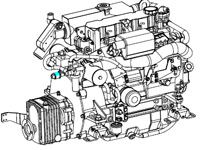 Westerbeke 44B Drawings |
 Westerbeke 44B Specifications |
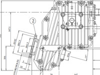 ZF-15 Installation |
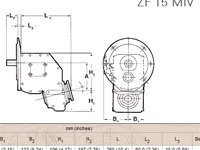 ZF-15 Drawings |